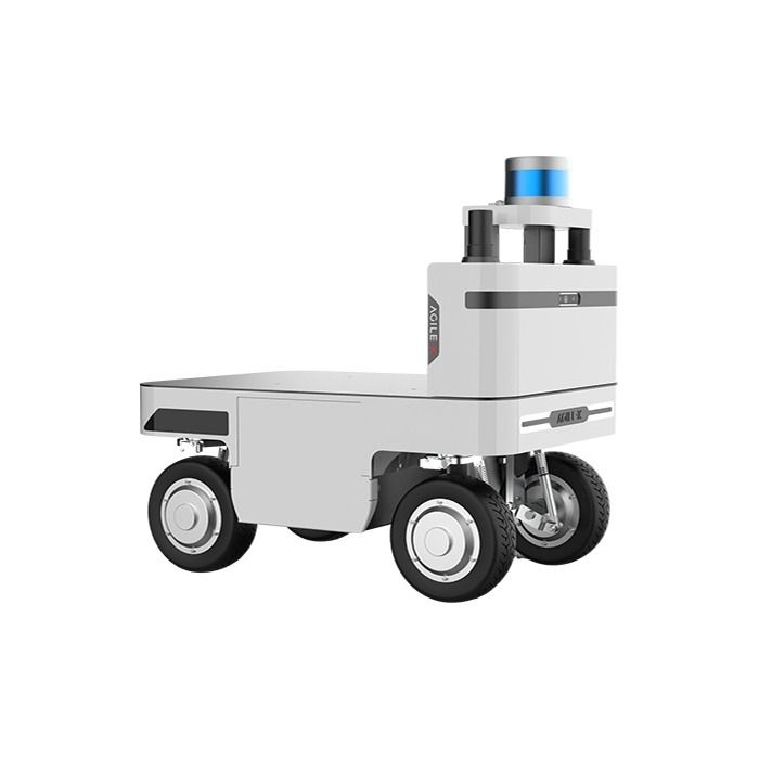
Agilex NAVIS Autonomous Navigation System
In stock
- BRAND:
- AGILEX
- PART #:
- NAVIS
- ORIGIN:
- China
- AVAILABILITY:
- SUBJECT TO AVAILABILITY
- SKU:
- AgileX-NAVIS
Agilex NAVIS Autonomous Navigation System
Every warehouse, plant floor and service corridor is redrawn a little each day: a pallet stacked where none stood yesterday, a temporary partition put up for maintenance, a loading bay reopened at the far end of the building. A map drawn once and never touched soon becomes a liability. The Agilex NAVIS Autonomous Navigation System is designed around that reality. It pairs One-Click Mapping with tools that let operators edit the map while the robots keep working, so that autonomy follows the site rather than forcing the site to stand still. NAVIS lets robots navigate both semi-enclosed and enclosed environments by integrating and processing data from their onboard sensors and systems.
Robots Middle East supplies the Agilex NAVIS Autonomous Navigation System to system integrators, research groups and facility operators across the Middle East. Our team prepares each quotation around the platform and site you intend to automate, coordinates delivery to your premises and remains your point of contact for technical support once the system is in service.
Background
AgileX Robotics and its platform approach
AgileX Robotics is known for mobile robot chassis and development kits used in research, education and industry. Its range, which you can browse in our AgileX category, is built on the idea that a capable base should be easy to extend with perception, manipulation and autonomy. NAVIS belongs to that logic. Rather than leaving each customer to assemble sensors, localisation software and planning tools from separate suppliers, AgileX offers a navigation system that can be added to industrial robots and AGVs as a coherent package, supported by documentation and integration tools from the same manufacturer.
Sensor fusion and a three-part system
At the heart of NAVIS is proprietary LiDAR-IMU sensor fusion. The system combines solid-state LiDAR, depth cameras and an IMU into a single sensor fusion platform that supports precise mapping, reliable obstacle detection and autonomous navigation. On top of that perception layer sit real-time path planning and adjustment, obstacle detection and avoidance, and intelligent decision-making algorithms. For the operator, NAVIS is organised into three core components: a Navigation Panel, a Task Management System and a Visual Feedback System. In hardware, the system follows a modular structure of NAVIS Brain, NAVIS Bridge and NAVIS Board, which allows it to be integrated flexibly into different UGV platforms.
Technical Specifications
| Specification | Value |
|---|---|
| Product type | Autonomous navigation system for semi-enclosed and enclosed environments |
| Mapping area | 2 mil. ㎡ |
| Mapping | One-Click Mapping |
| Navigation method | Proprietary LiDAR-IMU sensor fusion, real-time path planning and adjustment, obstacle detection and avoidance, intelligent decision-making algorithms |
| Sensors | Solid-state LiDAR, depth/stereo cameras, IMU |
| Positioning accuracy | approx. ±3-5 cm |
| Repeat position accuracy | ±8cm |
| Travel positioning accuracy | ±10cm |
| Maximum navigation speed | up to approx. 2.5 m/s |
| Safety features | Collision avoidance, virtual barriers, emergency stop |
| Software features | Mapping, path planning, task management, fleet coordination |
| Map editing | Real-time map editing tools for on-the-fly adjustments |
| Remote takeover | Remote control for immediate human intervention or guidance |
| Integration | SDK, API, ROS2 compatibility |
| Core system components | Navigation Panel, Task Management System, Visual Feedback System |
| Modules | NAVIS Brain, NAVIS Bridge, NAVIS Board |
| Dashboard | Custom data dashboard for desktop or mobile device |
| Scope of delivery | NAVIS Brain (main processing unit), wiring harness and mounting accessories |
Specifications are as published by the manufacturer and are confirmed against the datasheet at quotation.
The manufacturer has not published the dimensions, weight, power supply, power consumption, LiDAR model and range, camera resolution, operating temperature, IP rating, communication interfaces or a list of supported chassis; these details are confirmed at quotation.
How does NAVIS keep pace with a site that keeps changing?
The weakness of many navigation deployments is not the first map but the tenth week of operation, when the building no longer matches it. NAVIS addresses this in three layers. First, mapping itself is meant to be quick: One-Click Mapping reduces the effort of surveying an area, and the system covers a mapping area of 2 mil. ㎡, enough for large facilities to be handled within a single navigation environment. Second, the map is not frozen once it has been created. Real-time map editing tools let operators make on-the-fly adjustments to reflect environmental changes or new operational requirements, such as a closed aisle or a newly designated work zone. Virtual barriers fit naturally into that workflow, marking areas a robot must not enter without any physical change to the floor.
Third, NAVIS accepts that no autonomous system should be left entirely on its own. Remote control functionality allows immediate human intervention or guidance when necessary, so an operator can take over a robot that meets an unusual situation rather than sending staff to recover it. Alongside collision avoidance and an emergency stop, this gives safety and operations managers a clear chain of control: the robot plans and adjusts its own path in real time, and a person can step in whenever the situation calls for it.
What does NAVIS offer an integrator working with ROS2?
For an engineering team, the practical question is how much work stands between unpacking the hardware and running a robot on a live site. AgileX supplies NAVIS with a comprehensive SDK, an API and ROS2 compatibility, together with detailed implementation guides and technical support, so that the system can be integrated into industrial robots and AGVs without rebuilding a navigation stack from first principles. The modular split between NAVIS Brain, NAVIS Bridge and NAVIS Board helps here, because each module has a defined role within the overall system and the arrangement is intended for different UGV platforms.
Above the robot level, the software features extend to task management and fleet coordination, which matters as soon as a project grows beyond a single unit. The Task Management System organises what the robots are asked to do, the Visual Feedback System shows what they are doing, and a custom data dashboard turns operational data into visualisations for real-time insight and analytics on any desktop or mobile device. An integrator can therefore present a customer with a working operations view rather than raw logs.
Who is NAVIS for?
The first group is system integrators and AGV builders who need a dependable navigation layer for their own vehicles and prefer to concentrate their engineering effort on the application, whether that is transport, inspection or handling. The SDK, API and ROS2 compatibility are aimed squarely at this audience. The second group is manufacturers and logistics operators who already run industrial robots or plan to, and who want autonomy that can be maintained by their own staff through map editing, task management and remote takeover rather than by repeated visits from a specialist.
The third group is universities and research laboratories working on mobile robotics, where a ready-made sensor fusion platform with ROS2 support frees researchers to study planning, fleet behaviour or human-robot interaction instead of rebuilding localisation. Finally, facility managers in large enclosed or semi-enclosed sites will value the extensive mapping area and the safety features when considering several robots working across a whole building. The fact sheet names no alternative versions of NAVIS; if your project calls for a complete mobile platform rather than a navigation system alone, our AgileX category is the place to compare the wider range, and Robots Middle East can advise on the combination.
What is NAVIS used for?
- Warehouse intralogistics — moving goods between racking, staging areas and dispatch while routes are updated as the layout changes.
- Factory material transport — linking production cells with automated runs that plan around people, carts and obstacles in real time.
- Inspection rounds — sending robots on repeatable routes through enclosed plant rooms, tunnels or service corridors.
- Semi-enclosed sites — operating under canopies, in covered yards and in partially open halls where indoor and outdoor conditions meet.
- Fleet coordination — assigning and tracking tasks across several robots from one dashboard on desktop or mobile.
- Research and teaching — giving laboratories a ROS2-compatible navigation platform for experiments in planning and autonomy.
Pricing and Availability
Robots Middle East quotes the Agilex NAVIS Autonomous Navigation System individually, because the right configuration depends on the robot or AGV it will run on, the size of the site and the integration work involved. Please tell us about your platform, your environment and the tasks you have in mind, and we will prepare a quotation that reflects them. Delivery, customs clearance and technical support are arranged together with the quotation. To begin, please use the quotation request available on this page.
Frequently Asked Questions
Which sensors does NAVIS combine?
NAVIS combines solid-state LiDAR, depth/stereo cameras and an IMU in a sensor fusion platform. Its navigation is built on proprietary LiDAR-IMU sensor fusion.
How large an area can NAVIS map?
The mapping area is 2 mil. ㎡, and maps are created with One-Click Mapping.
Can the map be changed once the robots are in service?
Yes. Real-time map editing tools allow on-the-fly adjustments for environmental changes or new operational requirements, and virtual barriers can restrict where robots may travel.
Does NAVIS support ROS2?
Yes. NAVIS offers ROS2 compatibility alongside an SDK, an API, detailed implementation guides and technical support for integration into industrial robots and AGVs.
What is included in the delivery?
The scope of delivery comprises the NAVIS Brain main processing unit together with a wiring harness and mounting accessories. Robots Middle East confirms the exact contents with your quotation.
Will NAVIS work with my robot chassis?
NAVIS is designed for flexible integration into various UGV platforms through its NAVIS Brain, NAVIS Bridge and NAVIS Board modules. Please share your platform details with Robots Middle East so that compatibility can be confirmed at quotation.
Where can I buy the Agilex NAVIS Autonomous Navigation System and what does it cost?
You can buy it from Robots Middle East, which supplies customers across the Middle East. The cost depends on your configuration and project, so we prepare a tailored quotation on request from this page.
Summary
A navigation system earns its keep not on the day the first map is drawn but in the months that follow, as aisles move, zones change and more robots join the fleet. The Agilex NAVIS Autonomous Navigation System is built for that long view: LiDAR-IMU sensor fusion and real-time path planning for the robot, One-Click Mapping and live map editing for the site, remote takeover and virtual barriers for the people responsible for safety, and an SDK, API and ROS2 compatibility for the engineers who integrate it. Robots Middle East supplies, delivers and supports it across the region. If you want your robots to keep up with a building that never stays the same, this page is the starting point.