
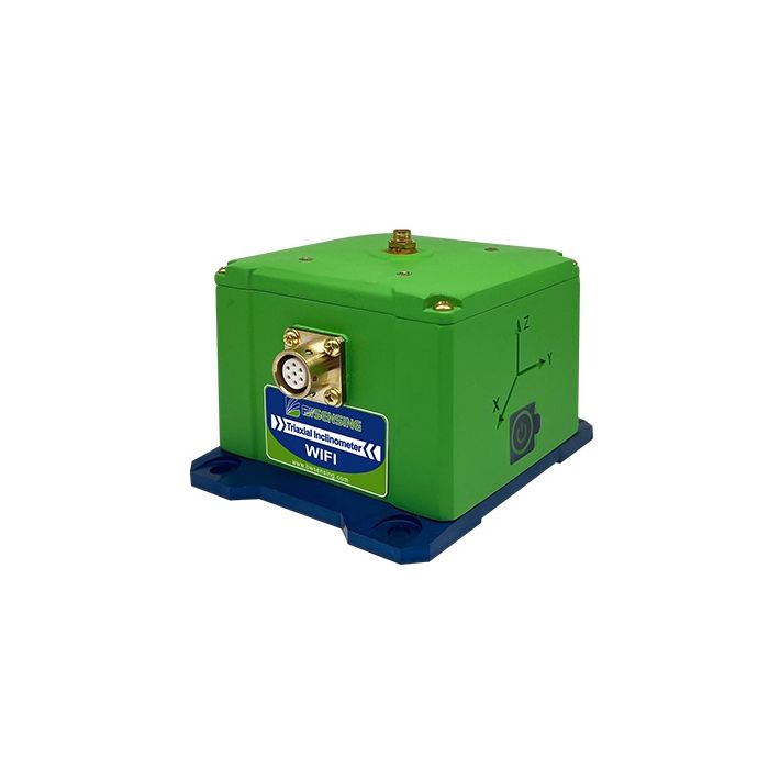
BWSENSING High-Speed Wifi Triaxial Inclinometer (WF-WM400)
In stock
- BRAND:
- BWSENSING
- PART #:
- WF-WM400
- ORIGIN:
- China
- AVAILABILITY:
- SUBJECT TO AVAILABILITY
- SKU:
- BWSENSING-WF-WM400
BWSENSING High-Speed Wifi Triaxial Inclinometer (WF-WM400)
A survey crew can tell you exactly where a structure stood on the day it visited; what happened in the weeks between visits is usually guesswork. The BWSENSING High-Speed Wifi Triaxial Inclinometer (WF-WM400) closes that gap by remaining on the structure permanently, measuring inclination on three axes and reporting wirelessly over WiFi. Instead of an occasional snapshot, engineers receive a continuous record of how a bridge tower, retaining wall or cut slope behaves through every season. It resolves angles to 0.001°, and its battery lasts more than three years at one upload per hour.
Robots Middle East supplies the WF-WM400 to contractors, engineering consultants, asset owners and research institutions across the Middle East. We prepare each quotation, arrange delivery and customs clearance to your project location, and remain your point of contact for technical questions before, during and after installation. Our team can also discuss the other wireless versions in the same family, so that the communication method matches the conditions of each site.
Background
Wuxi Bewis Sensing Technology LLC
The WF-WM400 is manufactured by Wuxi Bewis Sensing Technology LLC, the company behind the BWSENSING brand. Its range covers inclination and tilt sensing for industrial and civil applications, from wired single-axis and dual-axis inclinometers with analogue, CAN or Modbus outputs to wireless instruments for remote monitoring. Buyers who wish to compare the wider line-up can browse the BWSensing range in our catalogue.
Within that range, the WF-WM400 belongs to the instruments built for structural health monitoring. The manufacturer describes it as a compact and intelligent digital inclination sensor designed for that purpose, and its housing, sealing and power system all reflect long-term outdoor deployment rather than laboratory or machine-mounted use.
One sensor, three ways to report
The sources name three versions of this design, distinguished by how the data leaves the sensor: the WF-WM400 communicates over WiFi, the LWHD-WM400 over LoRaWAN, and the FG-WM400-EU over 4G LTE Cat-1. This page covers the WiFi version, the WF-WM400, and every figure given here belongs to it. The WiFi approach suits sites where a local network or gateway can be placed within reach of the sensors, and where engineers want a straightforward wireless link without cabling each measuring point back to a logger.
Technical Specifications
| Specification | Value (WF-WM400) |
|---|---|
| Measurement | Triaxial, range ±60° |
| Resolution | 0.001° |
| Accuracy | 0.005° |
| Output frequency | Up to 50 Hz |
| Operating temperature | -40℃ ~ +85℃ |
| Protection level | IP68 (1 m water depth, 24 hours continuous test) |
| Shell material | ABS+30% glass fiber + magnesium aluminum alloy anodized base |
| Installation | Four M6 screws |
| Connector | Aviation connector |
| Dimensions (antenna not included) | L105.2*W85*H76 (mm) |
| Standard antenna height | 159mm (WiFi version without radome) |
| Weight | 450 (±10) (with battery) |
| Power supply voltage | 3.6VDC~5VDC |
| Disposable battery capacity | 19000mAh |
| Communication distance | Maximum: 200m |
| Battery life | More than 3 years when uploading data once an hour |
| Power saving and wake-up | Automatic sleep mode, timed wake-up and exercise wake-up |
Specifications are as published by the manufacturer and are confirmed against the datasheet at quotation.
The manufacturer has not published the WiFi standard version, the operating humidity, software compatibility or details of a cloud platform; these points are confirmed with you at quotation.
Why choose a wireless triaxial inclinometer over a cabled one?
On a long bridge, a dam crest or a slope above a highway, the cost of a monitoring scheme often lies less in the sensors than in the cable: trenching, conduit, protection against damage and the repairs that follow when a cable is cut. The WF-WM400 removes most of that work. Each unit is fixed with four M6 screws, carries its own disposable battery and sends its readings over WiFi across a communication distance of up to 200m, so a measuring point can be added where the engineering calls for it rather than where a cable route happens to be convenient.
Triaxial measurement adds a further advantage. With a range of ±60° on each axis, the sensor records tilt in every direction in which a structure may move, rather than only along one pre-selected plane. Combined with a resolution of 0.001° and an accuracy of 0.005°, this allows slow, progressive movements to be identified early. The output frequency of up to 50 Hz means the same instrument can also capture faster changes when the monitoring programme requires it, while the sleep and wake functions keep routine operation economical.
How long can the WF-WM400 stay in the field?
Durability rests on three elements. The first is power: the 19000mAh disposable battery gives more than three years of service when data is uploaded once an hour, and the automatic sleep mode, timed wake-up and exercise wake-up keep the sensor inactive between readings unless movement calls for attention. The second is the enclosure: a shell of ABS with 30% glass fibre on an anodised magnesium-aluminium alloy base, sealed to IP68 and tested at 1 m water depth for 24 hours continuously. The third is the temperature range of -40℃ to +85℃, which covers both the heat of summer on exposed steel and concrete and cold nights at altitude.
For projects in the Gulf and the wider region, that combination matters. Sensors on bridges, towers and slopes are exposed to strong sun, sand-laden wind and occasional heavy rain, and every site visit to replace a battery or reseal a housing adds cost and risk. The aviation connector and screw-fixed base support a robust, repeatable installation, and the expected battery life allows a monitoring programme to run for years with minimal intervention.
Who is the BWSENSING High-Speed Wifi Triaxial Inclinometer (WF-WM400) for?
The WF-WM400 is aimed first at structural and geotechnical engineers responsible for the long-term behaviour of bridges, dams, towers, tunnels, retaining structures and slopes. Engineering consultancies that design monitoring schemes will value the absence of cabling and the triaxial range; main contractors can use it to watch adjacent buildings and temporary works during excavation; and asset owners can install it as part of a permanent health-monitoring programme.
Universities and research institutes also benefit, since the fine resolution and selectable reporting allow both slow deformation studies and higher-rate tests. Where the site cannot place a WiFi receiver within reach of the sensors, the same design is available in LoRaWAN (LWHD-WM400) and 4G LTE Cat-1 (FG-WM400-EU) versions, and Robots Middle East can advise on which suits the project. For applications where a cabled, machine-mounted tilt sensor is the better fit, our Sensors category includes wired BWSENSING inclinometers, such as the BWSENSING Cost-Effective Dual-Axis Digital Output With Modbus Inclinometer (BWN427).
What is the BWSENSING High-Speed Wifi Triaxial Inclinometer (WF-WM400) used for?
- Bridge monitoring: tracking the tilt of towers, piers and abutments over the life of the structure.
- Dam safety: observing the inclination of dam bodies and associated structures through seasonal loading.
- Slope stability: detecting early movement on cuttings, embankments and hillsides for disaster prevention.
- Tunnel construction: monitoring linings and portals for deformation during and after excavation.
- Foundation pits: watching retaining walls and neighbouring buildings while deep excavations proceed.
- Tall structures: recording the lean of towers, masts and historic buildings without permanent cabling.
Pricing and Availability
Robots Middle East supplies the WF-WM400 on quotation, so that the version, quantity and accessories match the requirements of your project. Tell us about the structure, the number of measuring points and how you intend to collect the data, and our team will prepare a tailored offer. Delivery, customs clearance and technical support are arranged together with the quotation. To begin, use the quotation request available on this page.
Frequently Asked Questions
What measurement range does the WF-WM400 cover?
It measures on three axes with a range of ±60°, at a resolution of 0.001° and an accuracy of 0.005°.
How far can the sensor transmit over WiFi?
The maximum communication distance is 200m. Site layout and obstructions should be reviewed when planning receiver positions.
How long does the battery last?
The 19000mAh disposable battery provides more than three years of operation when data is uploaded once an hour, supported by automatic sleep mode and timed and exercise wake-up.
Can it be installed outdoors in harsh conditions?
Yes. It is rated IP68, tested at 1 m water depth for 24 hours continuously, and operates from -40℃ to +85℃.
How is the sensor mounted?
It is fixed with four M6 screws to its anodised magnesium-aluminium alloy base and uses an aviation connector.
Are there other communication options?
Yes. The same design is offered as the LWHD-WM400 with LoRaWAN and the FG-WM400-EU with 4G LTE Cat-1; Robots Middle East can advise on the right choice.
Where can I buy the BWSENSING High-Speed Wifi Triaxial Inclinometer (WF-WM400) and what does it cost?
You can buy it from Robots Middle East, which supplies it across the Middle East. Pricing is provided on quotation, tailored to your quantity and project requirements.
Summary
Periodic surveys show where a structure stood; the WF-WM400 shows how it moved in between. Fixed permanently to a bridge, dam, tunnel or slope, it measures tilt on three axes with fine resolution, reports over WiFi without cabling, withstands immersion and extreme temperatures, and runs for years on its own battery. For engineers who need that continuous record, and for Robots Middle East customers planning a monitoring scheme across the region, this page is the starting point.